Nimbo is a stunning tool for visualizing the evolution of continental surfaces using Copernicus Sentinel data. Even better, they can be further enhanced with the DEM service provided by Nimbo Terrain to observe and use them in a 3D environment.
What is a Digital Elevation Model (DEM) and what can I do with it ?
A word, first, to explain what a DEM (Digital Elevation Model) is, and avoid confusion with similar products such as DTM (Digital Terrain Model). They are both digital representations of the Earth’s surface, specifically its elevation or terrain features. While they are related and often used interchangeably, there are some key differences between them:
– a DEM represents the elevation of the Earth’s surface, including both natural terrain features like mountains, valleys, and rivers, as well as man-made structures like buildings and bridges. It includes all surface features and is not limited to just the bare terrain. Be aware that they may require additional processing or filtering to isolate the bare Earth elevation if that is the specific requirement.
– a DTM, on the other hand, specifically represents the bare Earth’s surface or the natural terrain without the inclusion of man-made structures. It filters out buildings, vegetation, and other human-made features to focus solely on the topography. As a result, they inherently represent the bare Earth’s surface.
DEM and DTM are used in a wide range of applications, including urban planning, flood modeling, hydrology, terrain analysis for agriculture or forestry and also 3D visualization. They are suitable for applications where both natural and man-made features are relevant.
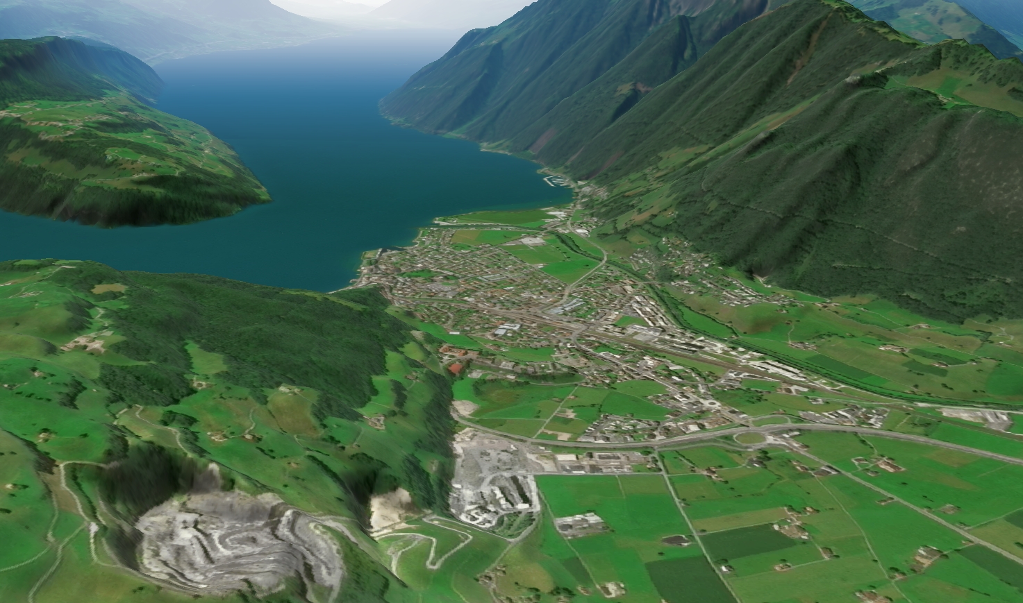
3D satellite view of Brunnen, Switzerland © Nimbo by Kermap, with modified Copernicus Sentinel data
Multiple sources of Global DEMs, multiple specifications
There are several sources of global Digital Elevation Models (DEMs) that provide elevation data for various regions of the world. These are some of the main sources of global DEM data. The availability and quality of DEMs may vary depending on the region and the specific mission or dataset. Users should choose the DEM source that best suits their application’s requirements in terms of spatial resolution, coverage, and accuracy.
Here we can list the main DEMs available on a global scale :
- Copernicus DEM (EU-DEM): The European Union’s Copernicus program offers a Digital Elevation Model known as EU-DEM. Copernicus DEM was acquired from the TanDEM-X mission between 2011 and 2015. The results were generated at 3 levels: the EEA-10 data at 10m spatial resolution covers European countries, the GLO-30 and GLO-90 at respectively 30m and 90m of spatial resolution which cover all the continental surfaces of the world. The Copernicus DEM has an absolute vertical height accuracy of less than 4m.While EEA-10 data is limited in terms of user license, the GLO-30 and GLO-90 products are distributed in opendata and constitute the most up-to-date and accurate data available free of charge.
- SRTM (Shuttle Radar Topography Mission) : SRTM is one of the most widely used global DEM datasets. It was collected during a NASA mission in 2000 and provides elevation data for most of the Earth’s land surface. SRTM data is freely available and typically has a spatial resolution of 30 meters (1 arc-second) for most regions with an absolute vertical height accuracy of less than 16m.
- ASTER GDEM (Advanced Spaceborne Thermal Emission and Reflection Radiometer Global Digital Elevation Model) : ASTER GDEM is another global DEM dataset that is freely available. It was created using data from the ASTER instrument on the Terra satellite. ASTER GDEM has a higher spatial resolution than SRTM, with a 30-meter pixel size.
- WorldDEM : WorldDEM is a high-resolution global DEM dataset provided by Airbus Defence and Space. It offers elevation data with a spatial resolution of 12 meters and is available for commercial use.
NIMBO : a new gateway to Copernicus DEM
Nimbo Terrain currently offers worldwide access to Copernicus DEM (EU-DEM) at a minimal resolution of 30m, and up to 1 m resolutions for specific geographies when available. In addition, it is important to note that it was supplemented by SRTM data on Armenia and Azerbaijan because this part of the territory is not initially available in the Copernicus DEM.
Easy access to DEM data with Nimbo Terrain
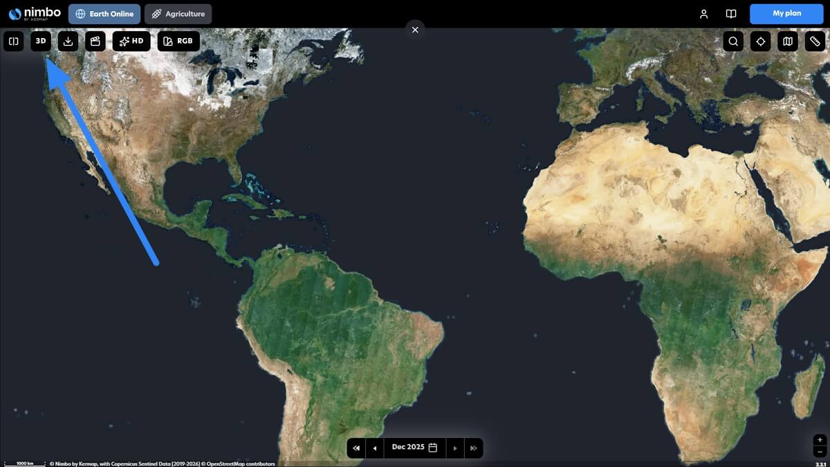
You can directly access the DEM from our NIMBO eath online platform. Simply activate the 3D view, using the corresponding button at the bottom right of the platform :
You can rotate the view 360° and change the viewing angle by holding down the Control key on your keyboard and right-clicking on your mouse (video)
Note that even in 3D mode, it is possible to benefit from all the regular features : you can thus modify the date displayed, switch to an infrared satellite view, NDVI or RADAR view. Last but not least, you can also produce and export split or swipe views, as well as timelapses.
Easy access to DEM data directly from the basemap service
This data is also available on basemaps in a TMS and WMTS service :
- TMS : The TMS service is available as a Terrain-RGB tiles product. Like the data provided by Mapbox, our DEM is encoded in the form of an 8-bit RGB image. This represents the advantage of having easy access to a large set of height values in 8-bit data. And above all, this allows for perfect interoperability with Mapbox tools and other derived solutions like Maplibre. Height calculation from Terrain-RGB tiles product:
height = -10000 + ((R * 256 * 256 + G * 256 + B) * 0.1) - WMTS : Nimbo Terrain offers a DEM product in WMTS at a resolution of 30m projected in EPSG:3857 (Pseudo Mercator). The data provided by the WMTS service is in float32. This allows the entirety of the Copernicus DEM and SRTM source data to be preserved. This data format opens up more possibilities for you, including defining color palettes on the fly according to your needs. Finally, the data is in COG. This means that our data provides you with optimal quality of service in terms of data refresh queries.
“Integration was effortless, Nimbo Terrain data makes our tool feel more trustworthy”
Erik Forsberg, Parametric Solutions – Read full story
With Nimbo Terrain, global DEM as easy as it gets
Nimbo Terrain offers you access to an elevation product on a global scale. This product is based on the Copernicus DEM (EU DEM) supplemented by the SRTM on the missing parts. We provide access to this data in different forms. Through our platform EarthOnline, which allows you to benefit from a 3D view and to drape this information with Nimbo monthly basemaps. And also, a direct access via basemaps products in the form of a TMS service in Terrain-RGB tiles and a WMTS service. The TMS service provides you with:
- 8-bit encoded altitude information in RGB images which allows up to 0.1 meter height increments
- Data is accessible up to zoom 12
- Data that is perfectly interoperable with the Mapbox GL and MapLibre libraries
And with the WMTS service you get:
- Elevation information encoded in float32
- Information at 30m projected in EPSG:3857 (Pseudo Mercator)
- Information in COG format for better performance
Interested in Nimbo’s global DEM data services ? Give it a go on maps.nimbo.earth !