Infrared satellite imagery for Earth observation has been around since the 1960s. This beyond-the-human-eye set of data has been since providing precious information in such various domains as wheather forecasting, climate monitoring, environmental preservation, agriculture, geology, defense or natural disaster response. In other words, infrared imagery is a must-have for geospatial analysts, that naturally had to find its way on Nimbo Earth Online.
Infrared imagery : tapping the invisible part of the spectrum
In a nutshell, infrared technology comes down to capturing “images” of the Earth’s surface, by detecting the thermal radiation emitted by objects and landscapes in the infrared portion of the electromagnetic spectrum. This type of imagery is thus different from traditional visible light imagery, as it focuses on the heat energy emitted by objects rather than the reflection of visible light.
Specialized sensors are of course necessary to do what our eyes cannot. These sensors onboard satellites do not see per se : they measure the intensity of the said thermal radiation. Then this data is converted into visual images, conventionally translated in shades of red, suitable for the human eye.
A quick reminder here : visible light extends from wavelengths of 400 nm to 700 nm, while Infrared ranges from 700 nm to 1 mm. As for Nimbo Earth Online’s Infrared layers, they are based on the Near-Infrared portion of the spectrum, or NIR, captured by Sentinel 2 sensors, spanning from 705 to 865 nm. Meaning that that part of the spectrum very close to visible colors will not provide information on objects’ or surface’s heat signature. It is however, very, very useful.
Near-infrared data for Earth observation : why it matters
As we stated earlier, there are a lot of applications for infrared imagery based on thermal detection, but we will focus here specifically on near-infrared imagery as this is the information you will find on Nimbo. There are two applications where this type of satellite data is especially efficient.
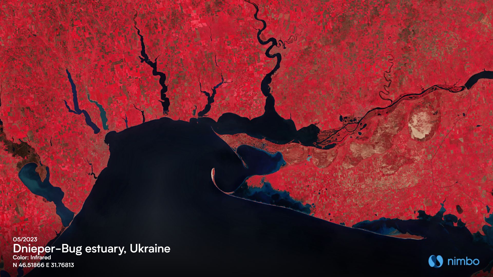
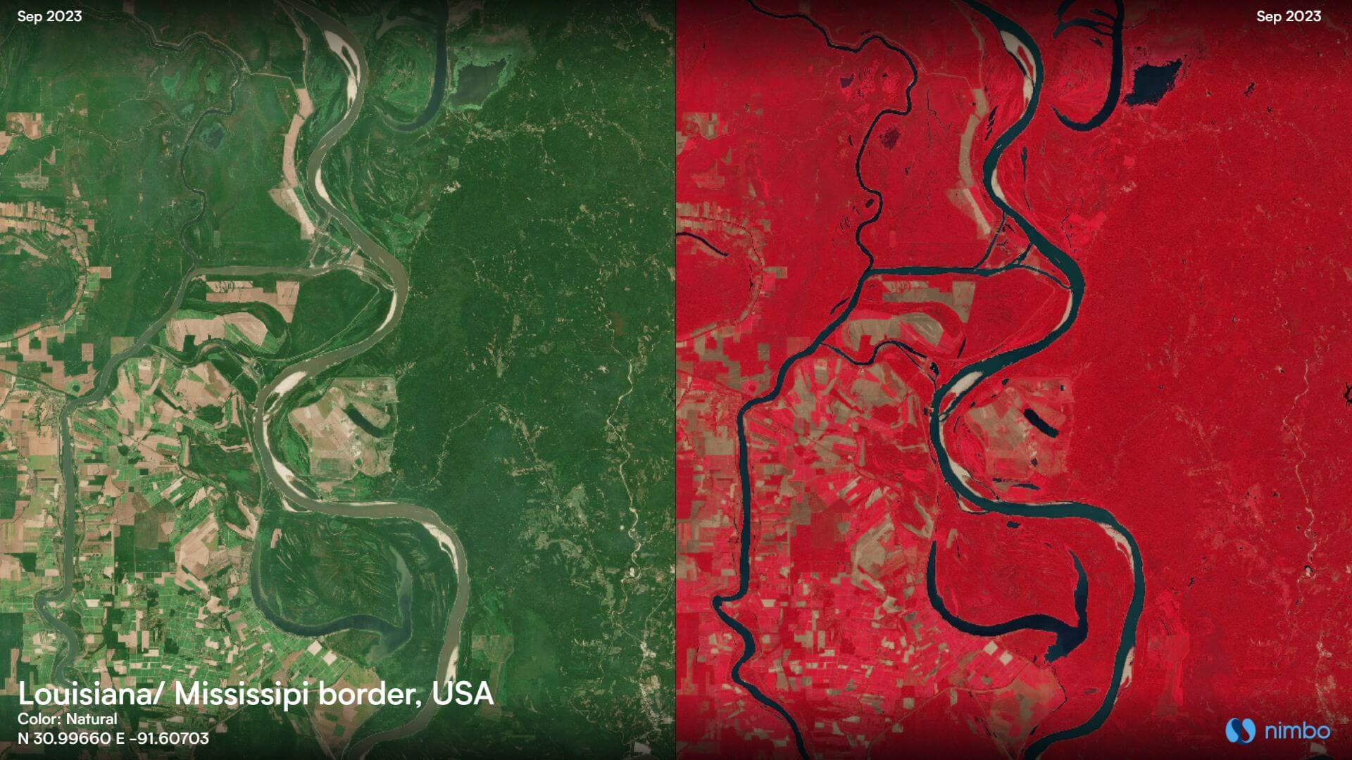
The first one is detecting water bodies. Of course, satellite data in natural colors let oceans, rivers, lakes and so forth reveal themselves to the naked eye. But sometimes things are not as clear cut. Think for instance of troubled waters, that will appear in shades of brown in RGB satellite views (ie natural colors) and thus sometimes barely stand out. Using near-infrared imagery is a no-miss way to identify all that is water on Earth’s surface,as illustrated below:
The other field where near-infrared satellite data proves particularly relevant is assessing vegetation health. Indeed, when plants are photosynthetically active and vibrant, they absorb most of the visible light for photosynthesis, but reflect a significant portion of the near-infrared light. NIR data can thus provide direct information on vegetation vitality to assess wether natural environments are in good condition. Especially useful in times of water stress, that are bound to become more and more frequent and intense as climate change effects sink in. Crucial information also, for agriculture, as infrared imagery helps detect all kinds of drops in crop vitality, caused by water deprivation or other climate-related cause, but also diseases and pests.
With Nimbo, an infrared map of the Earth every month
Getting information on water presence and vegetation health through NIR data is useful. Having the oppportunity to monitor this information month after month with cloud-free maps is even better. That is what Nimbo provides you with: a basemap of the Earth in infrared, cloud-free, and updated every month. Precious material to track land evolutions throughout the year, or from one year to another, thanks to super-easy comparison features available on the Earth Online web platform. But also analysis-ready infrared basemaps, fit for machine-learning operations and extra-easy to upload on a GIS software like QGIS. All you need is a Nimbo account, sign up for free on maps.nimbo.earth to give it a go !