As free access to NICFI’s groundbreaking forest monitoring satellite imagery winds down, a new solution is stepping up. Nimbo Earth Online now offers monthly, cloud-free mosaics that help overcome one of the toughest challenges in tropical forest observation: persistent cloud cover. By combining advanced cloud removal with pixel-level traceability, Nimbo ensures that users can keep monitoring forests effectively, even as NICFI data disappears.
NICFI satellite imagery and its importance for forest monitoring
The Norwegian government’s International Climate and Forests Initiative (NICFI) Satellite Data Program, in partnership with Planet and others, transformed the way tropical forests were monitored. For the first time, free high-resolution satellite imagery was provided to governments, NGOs, indigenous peoples, and researchers working on forest monitoring, biodiversity protection, and climate commitments. These mosaics, updated monthly, were vital in exposing illegal logging, tracking deforestation, and enabling accurate carbon reporting.
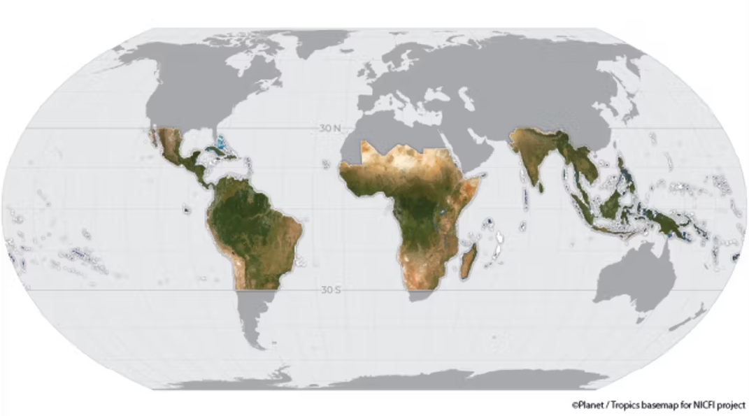
This open-access model made NICFI a global reference point in satellite imagery for forest monitoring, proving how powerful regular, cloud-free mosaics could be in the fight against tropical deforestation. Unfortunately, in early 2025, NICFI’s contract with Planet expired, and in September 2025 the Norwegian government announced the cancellation of the procurement process for the next phase. This decision left users worldwide searching for a reliable NICFI alternative.
How the end of NICFI data supply affects users
NICFI structured access into different levels of data:
- Level 0: Free, view-only mosaics for public awareness platforms like Global Forest Watch.
- Level 1: Downloadable, analysis-ready mosaics (including NIR) available through APIs and platforms like Google Earth Engine.
- Level 2: Access to all Level 1 products plus the original Planet scenes and some historical Airbus SPOT archives.
When the program ended in January 2025, Level 0 and Level 1 were temporarily extended but began to be phased out by April 2025. For example, Planet imagery via NICFI is no longer available on Collect Earth Online as of April 1, 2025. Level 2 access was not renewed at all. With the cancellation of the next-phase tender in September 2025, continuity of free high-resolution satellite imagery for tropical forest monitoring has become highly uncertain. Users must now turn to alternatives.
Nimbo as the perfect NICFI alternative for tropical forest monitoring
As the NICFI imagery program winds down, Nimbo positions itself as the ideal NICFI alternative for tropical forest monitoring. Unlike a stopgap solution, Nimbo offers a robust, long-term option built around continuity, affordability, and upgraded capabilities.
Nimbo’s monthly mosaics derive from Sentinel‑2 satellite imagery, processed with advanced cloud masking and compositing pipelines. In addition, Nimbo applies AI-powered super‑resolution enhancements to deliver an effective 2.5 m resolution mosaic product—double the spatial detail that many users expect from formerly free NICFI/Planet imagery.
Meanwhile, Planet has launched its Tropical Forest Observatory (TFO) as a paid service to retain former NICFI users. The TFO offers 5 m mosaics at a starting price of about US$ 180/month. This marks a clear shift: what was once provided for free under NICFI is now monetized.
Why Nimbo is more relevant than ever for former NICFI users
For practitioners, the need is clear: they require a trusted NICFI alternative that delivers the same functionality – monthly, cloud-free mosaics for tropical forest monitoring—without breaking the bank. Although not open-access, Nimbo’s online basemaps not only matches the spirit of NICFI’s mission and improves upon it:
- Higher resolution: 2.5m RGB super-resolution (AI-enhanced) compared to Planet’s 5 m.
- Lower cost: €80 per month (versus $180+ per month from Planet).
- Thematic data layers: NDVI and LAI
- User-friendly features for temporal comparison and tracking
- Ease of use: Simple integration into existing GIS tools and workflows
- Fast display with 50 to 200 ms average response time
The price is lower, and unlocks a value upgrade. Former NICFI users can transition to Nimbo and gain better resolution at less than half the cost of Planet’s new offer. Moreover, Nimbo’s mosaics integrate seamlessly into existing GIS or analysis workflows, meaning users don’t have to reinvent their processes.
Former NICFI users will not only maintain their established forest monitoring routines with Nimbo but also benefit from sharper imagery and a more sustainable pricing model. This makes Nimbo the most relevant and practical choice for continuing deforestation tracking and climate reporting, as illustrated by the integration of its satellite basemaps for forest monitoring in Nusantara Atlas, a platform produced by The Tree Map.
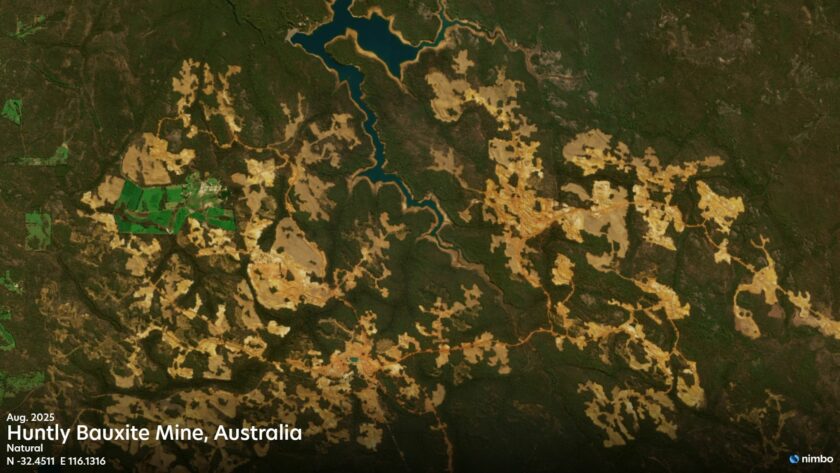
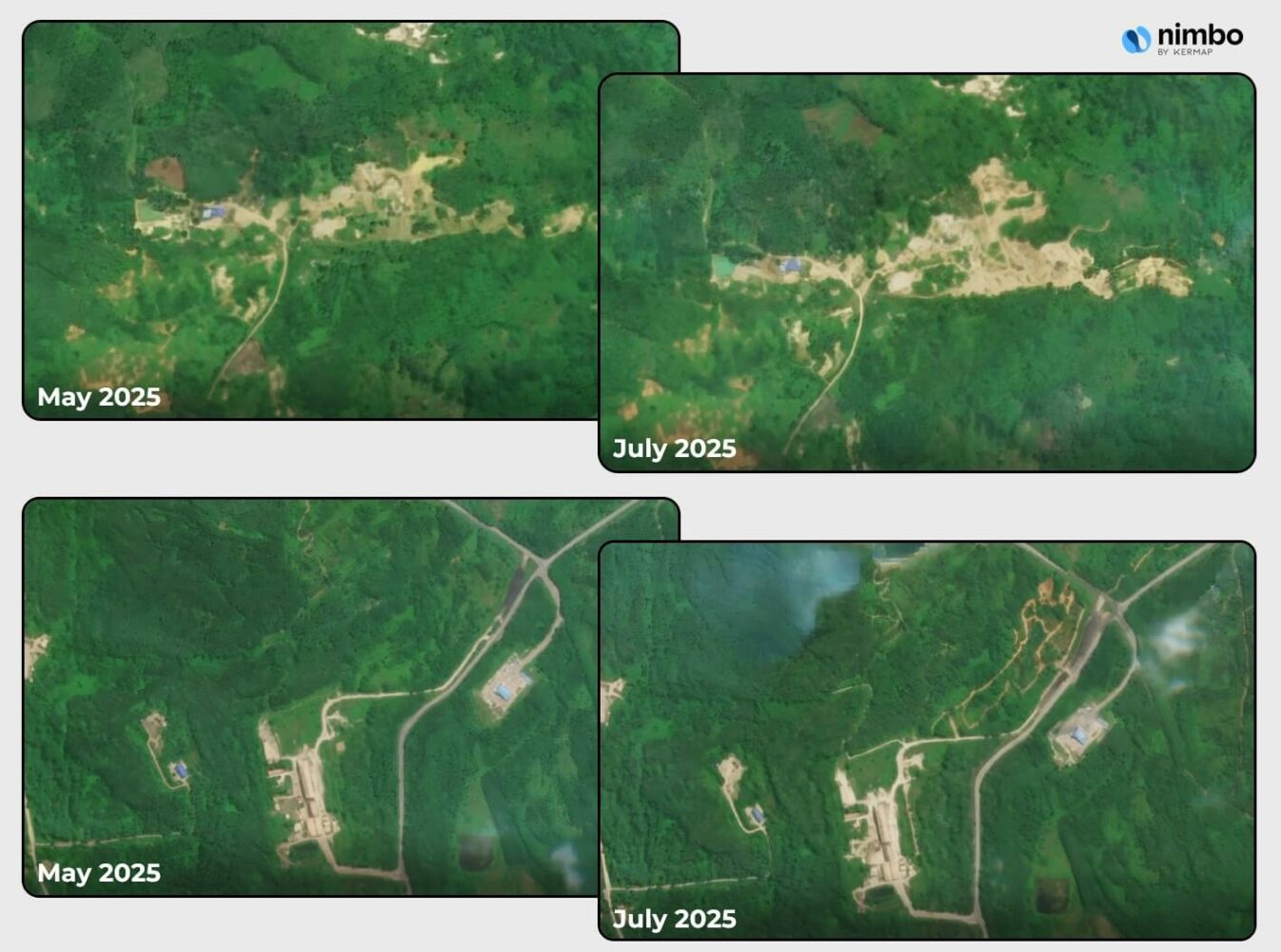
Sharper insights for forest monitoring with Nimbo Super Resolution
Nimbo Super Resolution unlocks finer spatial detail from existing satellite imagery, revealing changes in forest structure and land use that would otherwise go undetected. By enhancing image clarity beyond native sensor resolution, Nimbo enables the detection of subtle disturbances as possible early-stage deforestation signals, like small clearings or new paths – before they become visible in conventional imagery. This added precision empowers forest managers, researchers, and policymakers to act faster and with greater confidence.
A strong NICFI alternative already on the market
The end of NICFI satellite imagery is a setback, but it does not mean the end of effective tropical forest monitoring. Nimbo Earth offers a robust, affordable, and higher-resolution NICFI alternative that enables stakeholders to keep tracking deforestation and protecting biodiversity. With monthly updates, advanced cloud removal, and pixel-level traceability, Nimbo ensures that the essential work of forest monitoring can continue without interruption—and with even better tools than before. Get in touch with us to learn more on forest monitoring with Nimbo !