Nimbo HD Basemaps
Get the best resolution at global scale
Nimbo HD’s AI-enhanced satellite imagery delivers the highest resolution available at global scale, updated monthly.
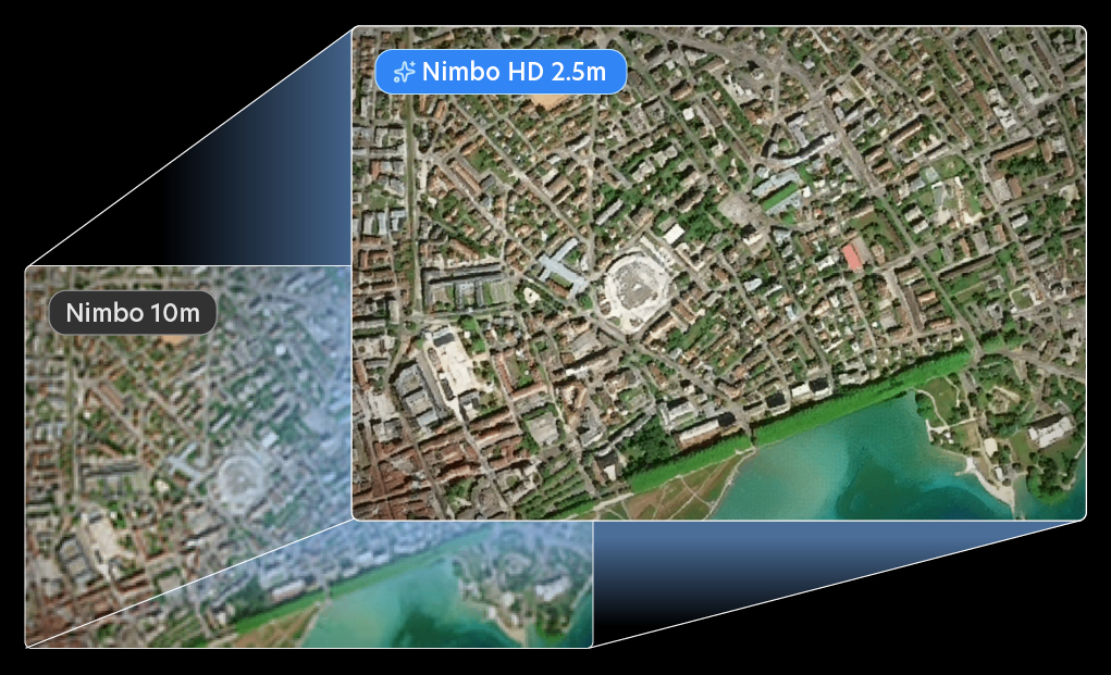
Access 2.5m Earth imagery that’s global, consistent, and easy to use.


2.5 m/px
Nimbo SR resolution
75%
of habitable land in routine production (rest of world on demand)
150ms
Average map response time
Earth as you need it
For the first time, 2.5m imagery is within your reach worldwide, every month.
Clear, global, up-to-date, simple to use, easy to integrate: it’s Earth as you need it.


Join the resolution revolution
Discover Nimbo Super-resolution on our Earth Online platform
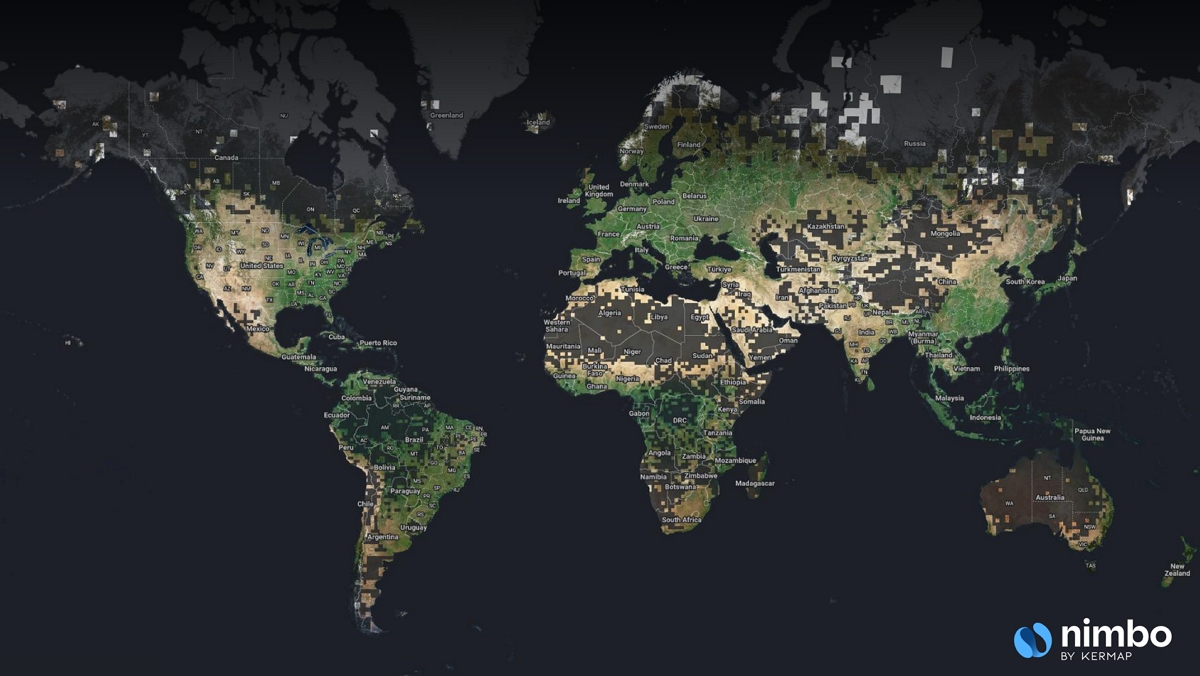
The global reference for 2.5m resolution
Nimbo extends super-resolution to a global scale, covering 75 % of the world’s habitable land in routine monthly production since May 2025. Your area’s not covered ? We add it on demand!
Included in your Nimbo Pro HD plan, this worldwide access isn’t limited to a country or continent.
You can now count on an autonomous gateway to high-detail Earth data: global, consistent, and always within reach.
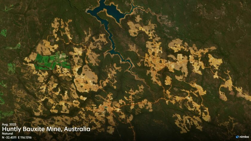
2.5M AT SCALE
Boost visibility on all terrains
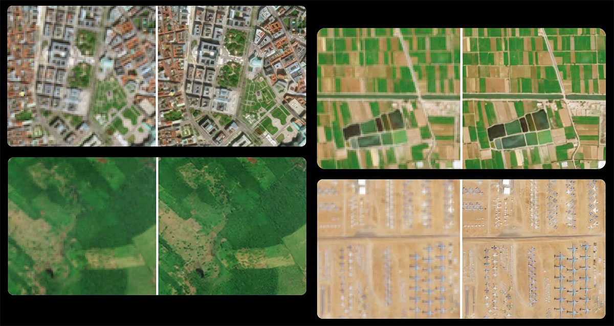
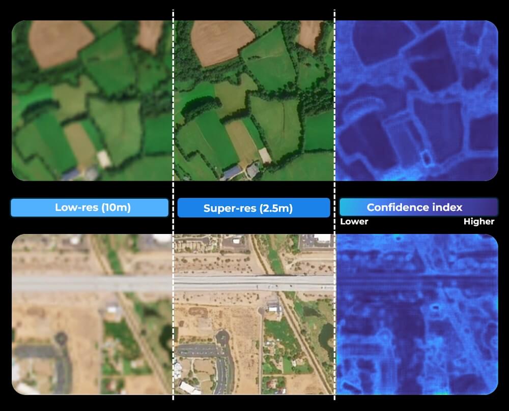
Nimbo HD’s Super-resolution process enhances the standard 10m Sentinel basemap to 2.5m resolution using advanced deep-learning models. It provides a new level of detail while maintaining global consistency and realistic natural colors.
Each month, the RGB Super-Resolution basemap is derived from the latest Nimbo 10m mosaic, making it the AI-enhanced, high-definition version of the Earth’s most up-to-date imagery.
Satellite data you can trust
Each Nimbo HD dataset comes with a confidence index layer, quantifying enhancement reliability at pixel level. This added layer brings full transparency to AI-enhanced super-resolution imagery — helping you assess, compare and rely on each pixel with confidence.
Your 2.5m digital twin of Earth, every month
Take the pulse of the planet in near-real time.
Each month, Nimbo HD refreshes a 2.5 m-resolution view of the Earth.
A consistent digital replica you can explore in 3D and integrate in your app for smooth visualization, anywhere.
Step up to super-resolution.
Discover the plans that bring global, monthly 2.5 m satellite imagery within your reach.
Save 33%
Discovery
0 € /month
- 2.5 & 10m resolution
- Full timeline
- Earth online platform (2D/3D)
- TMS / WMS access for GIS
2 test layers (watermarked)
- RGB HD
- RGB
Pro
From 20 € /month
- 10m resolution
- Full timeline
- Earth online platform (2D/3D)
- TMS / WMS access for GIS
3 layers (no watermark)
- RGB
- Infrared
- NDVI
Pro HD
From 45 € /month
- 2.5 & 10m resolution
- Full timeline
- Earth online platform (2D/3D)
- TMS / WMS access for GIS
4 layers (no watermark)
- RGB HD
- RGB
- Infrared
- NDVI
Enterprise
Your project
Everything in Pro HD, plus :
- LAI data layer
- NDVI monitoring
Advanced services
- Basemap integration
- Data download
- DEM
- Radar
Nimbo HD specs
| Description | Monthly AI-enhanced basemaps based on Nimbo’s monthly 10m composites |
| Availability | May 2025 to prior month |
| Update frequency | Monthly (published before the 15th of the next month) |
| Number of used bands | RGB :3 |
| Additional bands | – |
| Spatial Resolution | 2.5 m per pixel |
| Confidence Index | Yes (confidence layer with pixel-level uncertainty) |
| Global DEM | Up to 1 m |
| Bits depth | 8 bits |
| Measurement | Bottom Of Atmosphere (BOA) |
| Coordinate Reference System | UTM/WGS84 |
| Tile size | 110 x 110 km |
| Coverage | World |
| Format | TIFF |
| Access | TMS / WMTS compatible |
FAQ on Nimbo HD Basemaps
What are high-resolution satellite basemaps?
High-resolution satellite basemaps provide a more detailed view of the Earth than standard global imagery, allowing finer visual interpretation of landscapes, infrastructure, and land use, generally at 10m /pixel. Nimbo HD Basemaps bordering on very high resolution at 2.5 m per pixel and are designed for professional mapping and analysis.
What is the resolution of Nimbo HD Basemaps?
Nimbo HD Basemaps are delivered at 2.5 m per pixel, offering a significantly sharper level of detail compared to standard 10 m satellite basemaps, while maintaining global consistency and regular updates.
Why do Nimbo HD Basemaps revolutionize high-resolution satellite access ?
Most high-resolution basemaps (10 m) rely on yearly or quarterly updates at best, partial coverage, or imagery affected by clouds. Very high resolution imagery (<1m) can be scheduled to avoid clouds, but is much more expensive.
Nimbo HD Basemaps uniquely combine 2.5 m resolution, global coverage, cloud-free processing, and continuous monthly updates. They are also available under competitive plans, striking the right balance between precision, performance and affordability sought after by many professionals.
How often are Nimbo HD basemaps updated?
Nimbo basemaps are updated every month, providing a recent and reliable view of the Earth throughout the year. This regular refresh cycle helps ensure that changes on the ground are reflected quickly, while maintaining visual consistency across updates. Monthly updates strike a balance between freshness, stability, and global coverage for production platforms.
How are 2.5 m basemaps produced from satellite imagery?
Nimbo HD Basemaps are generated by enhancing high-quality satellite imagery using advanced AI techniques, including super-resolution methods, to increase visual detail while preserving spatial coherence across the globe.
Are 2.5 m basemaps suitable for monitoring changes over time?
Yes. Thanks to monthly updates and harmonized processing, Nimbo HD Basemaps make it possible to visually compare landscapes over time and identify changes with greater clarity than lower-resolution basemaps.Yes.
Can Nimbo’s high-resolution basemaps be streamed into GIS software?
The basemaps are served via TMS/WMTS protocols, making them compatible with most GIS software including QGIS and ArcGIS, and accessible through dedicated plugins or direct service URLs. More on Nimbo data in QGIS.
Can our high-resolution basemaps be used in web or 3D mapping applications?
High-resolution basemaps can be used in both 2D and 3D environments when optimized for streaming. Nimbo HD Basemaps are designed for smooth navigation and fast tile loading, making them suitable for interactive web maps and 3D visualization platforms.
What are geocredits and how do they work ?
Geocredits are a usage measure for how much you interact with the basemap streams (e.g., navigation, zoom, downloads). Every time you request a map tile (via TMS, WMS or WMTS), you spend one GeoCredit. More on the mapping tile system.
That’s it : 1 tile = 1 GeoCredit. Each subscription tier comes with a monthly geocredit allowance. Learn more on Nimbo Geocredits.