NIMBO Terrain
Bring elevation to your maps at global scale
Build richer maps, smoother 3D scenes and cleaner terrain visualizations with one global terrain stack.
NIMBO Terrain delivers elevation data through RGB DEM, seamless compatibility through Terrarium, and instant topographic rendering through Hillshade.
Perfectly aligned with NIMBO basemaps, these layers are ready to use in web maps, GIS software, 3D engines and broadcast workflows.


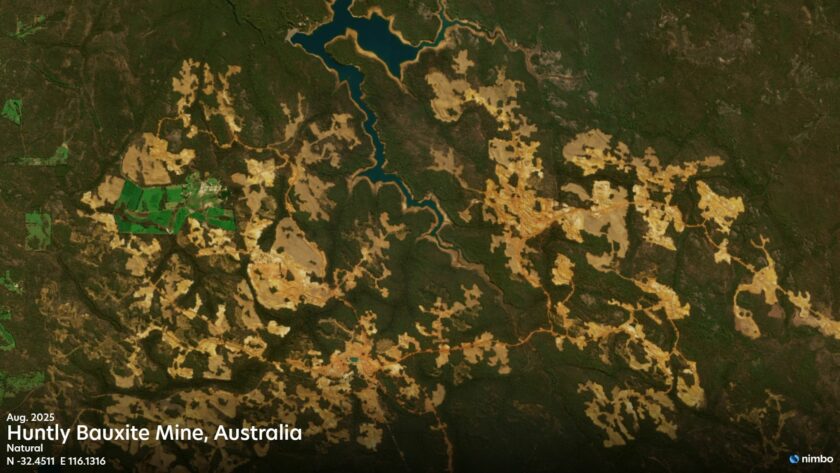
Up to 2m
NIMBO provides 2m elevation data for specific areas
9 Datasets
NIMBO combines national datasets
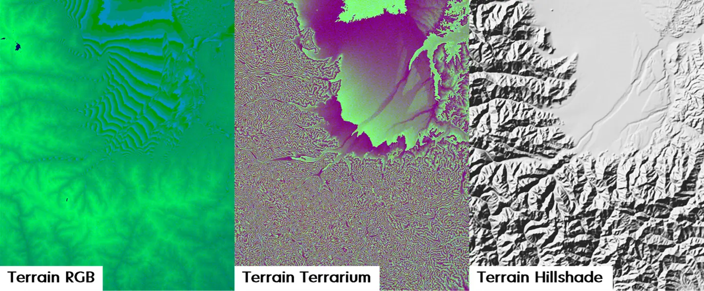
3 Layers
RGB DEM, Terrarium, Hillshade
A global terrain stack, ready to use
From terrain analysis to 3D visualization, NIMBO Terrain provides a seamless elevation foundation at global scale.
Use it to power terrain-driven applications, improve map readability, or build richer visual experiences with ready-to-use terrain layers.
Whether you need elevation values, Terrarium-compatible tiles or a shaded relief overlay, NIMBO Terrain helps you move faster from data to integration.

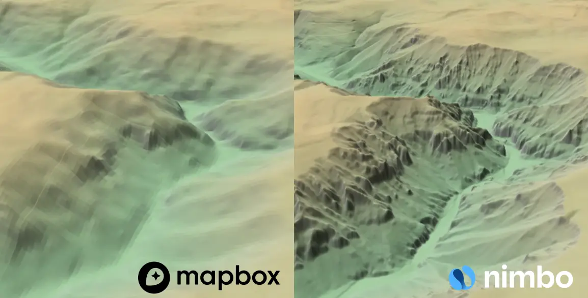
Built from the best available terrain sources
NIMBO Terrain combines the strength of global elevation models with higher-quality national datasets when available.
This hybrid approach gives you seamless worldwide coverage while unlocking much finer detail in selected countries, with resolution reaching up to 2m in some areas.
The result is a terrain layer that is global yet locally sharper, built for more realistic rendering, better topographic detail and stronger visual accuracy than standard global-only terrain products.
One terrain stack, three ways to work
- Use RGB DEM for elevation data, terrain analysis and advanced 3D rendering.
- Use Terrarium when your software or pipeline requires a widely supported terrain tile format.
- Use Hillshade to instantly enhance relief perception and improve the visual readability of image or vector maps.
Together, they give you a flexible terrain stack built for modern mapping, visualization, and production workflows.
Save 33%
Discovery
0 € /month
- 2.5 & 10m resolution
- Full timeline
- Earth online platform (2D/3D)
- TMS / WMS access for GIS
2 test layers (watermarked)
- RGB HD
- RGB
Pro
From 20 € /month
- 10m resolution
- Full timeline
- Earth online platform (2D/3D)
- TMS / WMS access for GIS
3 layers (no watermark)
- RGB
- Infrared
- NDVI
Pro HD
From 45 € /month
- 2.5 & 10m resolution
- Full timeline
- Earth online platform (2D/3D)
- TMS / WMS access for GIS
4 layers (no watermark)
- RGB HD
- RGB
- Infrared
- NDVI
Enterprise
Your project
Everything in Pro HD, plus:
- LAI data layer
- NDVI monitoring
Advanced services
- Basemap integration
- Data download
- DEM
- Radar
Q&A on Nimbo Terrain
What makes NIMBO Terrain different from a standard global DEM?
NIMBO Terrain is not just a single global elevation dataset. It combines global DEM sources with selected national high-resolution elevation models to deliver the best available terrain detail by country, with resolutions ranging from 2m to 30m depending on location. The result is a seamless global product designed for both visualization and analysis, and perfectly aligned with NIMBO basemaps.
Which Terrain format should I choose: RGB DEM, Terrarium, or Hillshade?
It depends on your workflow. RGB DEM is the best choice for modern web mapping, 3D rendering, and applications that need precise elevation values in a compact tile format. Terrarium is ideal for backward compatibility with legacy pipelines and engines that rely on the historic Mapzen encoding, including bathymetry. Hillshade is the easiest way to enhance visual relief instantly on top of satellite or vector maps when you want a strong cartographic effect without processing terrain yourself.
Can I use NIMBO Terrain directly in my existing GIS or 3D stack?
Yes. NIMBO Terrain is delivered through TMS / WMTS-compatible tile services and is designed to work with standard GIS and rendering tools. The RGB DEM format is explicitly documented as compatible with web mapping and 3D libraries such as MapLibre, Mapbox GL JS, OpenLayers, and Cesium, while Hillshade and Terrarium are also built for straightforward integration in GIS, rendering, and broadcast workflows.
Is NIMBO Terrain only for beautiful maps, or can it support real analysis too?
It supports both. NIMBO Terrain is built for 3D visualization, but also for practical terrain-driven workflows such as slope and aspect analysis, watershed studies, flood-risk modelling, solar exposure, and environmental assessment. For customers who need visual impact, the preprocessed Hillshade delivers immediate topographic clarity. For customers who need raw elevation values, RGB DEM and Terrarium provide the underlying terrain data for analysis and custom processing.
Why use NIMBO Hillshade instead of generating hillshade myself?
Because the visual result is better and the integration is faster. NIMBO Hillshade is pre-processed with cartographic enhancements such as adaptive lighting, contrast tuning, smoothing, and sharpening to avoid common issues like flat rendering, overly dark mountains, or visible tile-edge artifacts. Instead of spending time tuning hillshade parameters across zoom levels, you can use a ready-to-deploy layer that is optimized for global display and works especially well as an overlay on satellite imagery.
Which countries are covered by high-resolution national DEMs in NIMBO Terrain?
To provide the best possible detail, NIMBO Terrain integrates high-resolution national datasets into our global stack. Here is the current list of high-resolution local sources we use:
| Country | Dataset name | Native Resolution | NIMBO max zoom level | Source / Institution | Coverage & Notes |
| Austria | DGM Österreich | 10m | 14 | BEV / data.gv.at | Derived from LiDAR and photogrammetry; official national terrain model |
| France | RGE ALTI® | 1–5m | 14 | IGN (Institut national de l’information géographique et forestière) | Official national DEM, LiDAR and photogrammetry, full coverage of France |
| Italy | TINITALY DEM | 10m | 14 | INGV / University of Florence | Continuous DEM generated using advanced interpolation (TIN), covers entire Italian territory |
| Spain | MDT05 | 5m | 14 | Instituto Geográfico Nacional (IGN-CNIG) | Derived mainly from PNOA LiDAR, nationwide (including islands, Ceuta, Melilla) |
| Sweden | Markhöjdmodell (GSD-Höjddata grid 2+) | 2m (grid) | 17 | Lantmäteriet | High-resolution nationwide DEM from LiDAR surveys |
| Switzerland | SwissAltiRegio | 10m | 14 | Swisstopo | Annual updates, bare-earth model without vegetation/buildings, covers Switzerland + Liechtenstein, replaces DHM25 |
| United States | USGS 1/3 arc-second DEM (3DEP on request) | ~10m (2m on request) | 14 (17 on request) | U.S. Geological Survey (USGS NED/3DEP) | Nationwide seamless DEM, derived from LiDAR and photogrammetry, available via The National Map (public domain) |