Forestry & Forest Monitoring
See your forest clearly, every month
Largely cloud-free satellite imagery updated monthly, from the tropics to the boreal zone. Monitor deforestation, meet EUDR requirements, track wildfire risk, and report carbon stocks. No imagery preprocessing required. Ready for GIS integration via WMS and API.


THE CHALLENGE
Cloudy skies and outdated data
Rangers, carbon developers, compliance teams, and government agencies all need the same thing: a clean, current satellite view of their forest. In the tropics, that view is blocked for months. By the time a usable image is assembled, the clearing has expanded and the critical window has passed.
- Tropical forests obscured by cloud cover for months at a time.
- Manual processing consuming weeks before analysis can begin.
- Verification cycles that cannot wait for clear-sky conditions.
Nimbo delivers ready-to-use imagery
so your team can focus on forestry, not the data pipeline.
2.5 m/px
Spot access roads, clearings, and canopy disturbances invisible at lower scales.
Monthly basemap
AI processed, highly cloud-free imagery for consistent monitoring.
5 data layers
RGB, Infrared (NIR), NDVI, updated monthly — plus LAI and Sentinel-1 radar (SAR) on the Enterprise plan.
NICFI alternative
Most affordable replacement. Continuous monthly coverage.
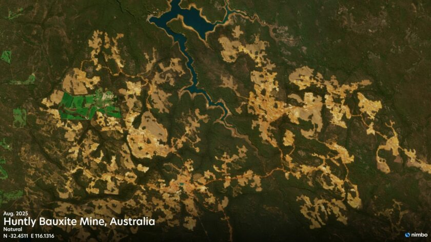
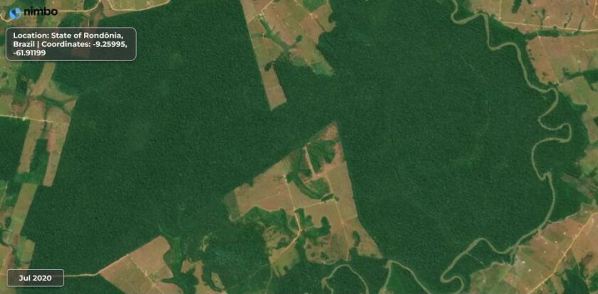
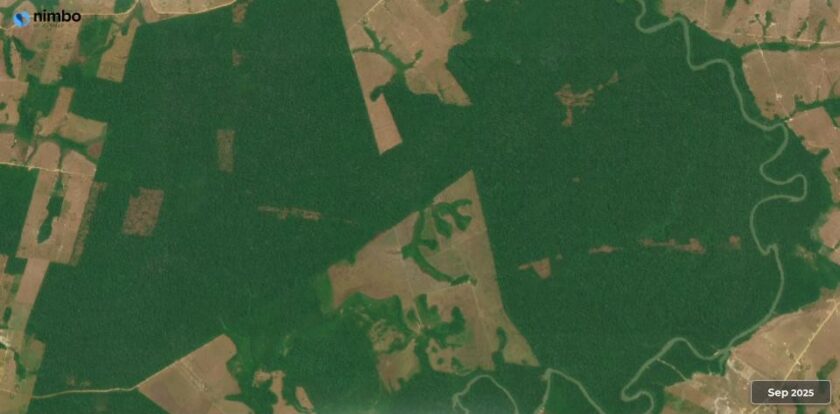
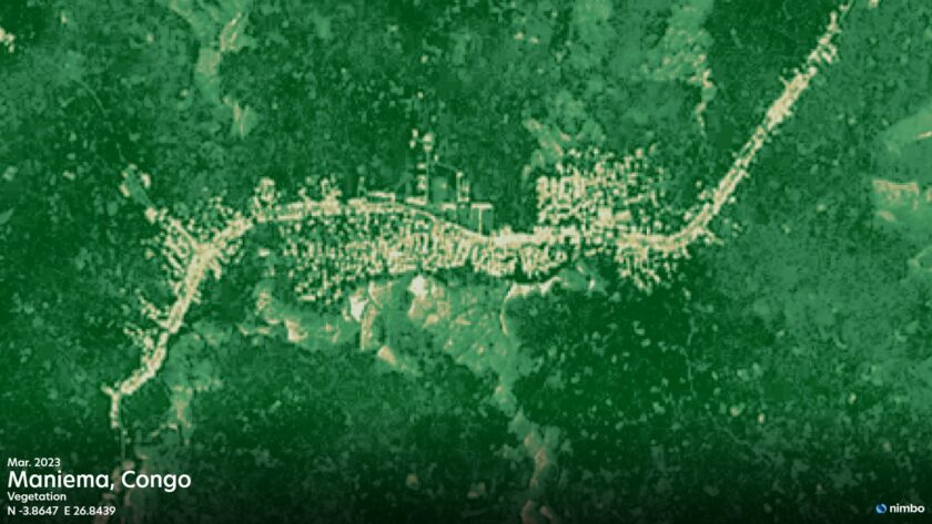
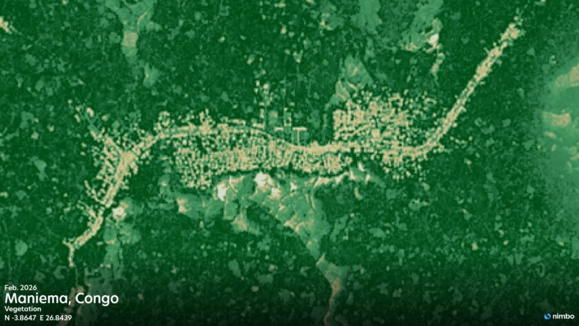
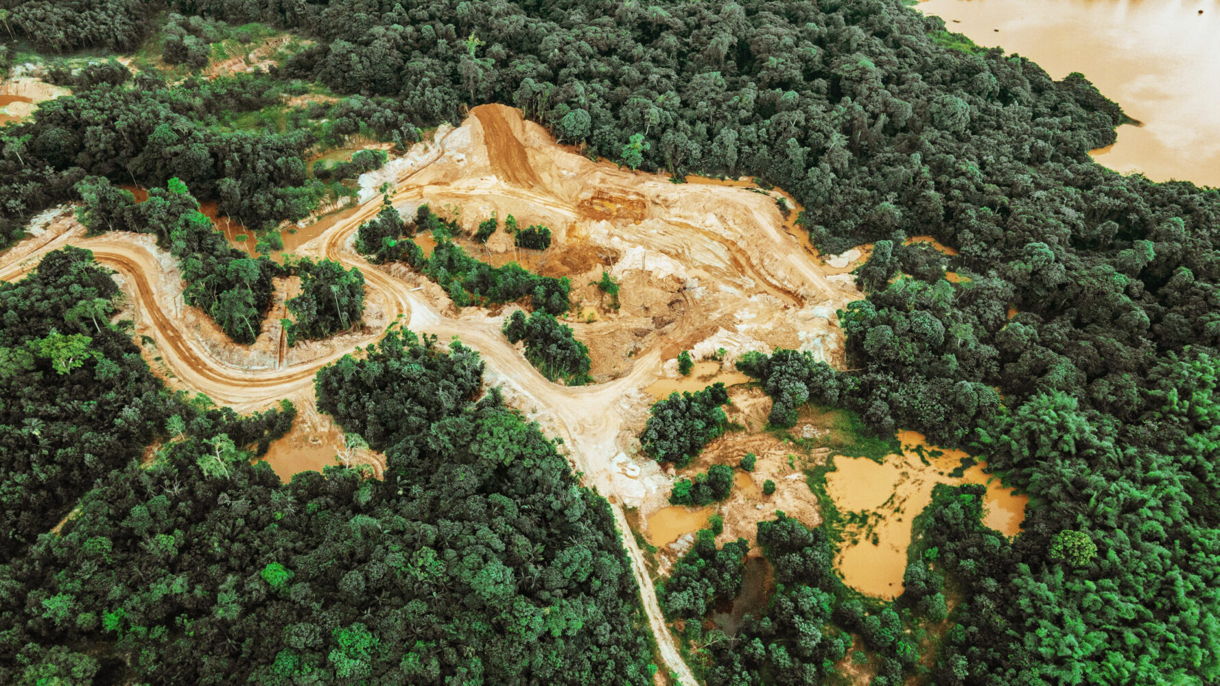
TROPICAL DEFORESTATION & ILLEGAL LOGGING
Monthly monitoring across tropical regions
Rangers and NGO analysts use Nimbo to seamlessly compare monthly changes across protected areas in the Amazon, the Congo Basin, and Southeast Asian rainforests. To overcome severe cloud cover during tropical monsoons, our system extracts the clearest optical pixels available to build a reliable monthly basemap. At 2.5 m super-resolution, teams can detect sub-hectare clearings and new access roads before they expand, with pixel-level timestamps for traceable, audit-ready documentation.
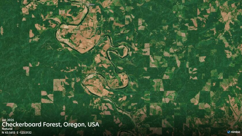
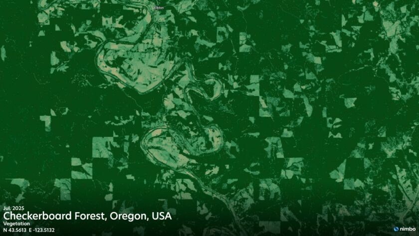
TIMBER HARVEST & FOREST OPERATION
Plantation tracking minus the field trips
Enable large-scale monitoring and replace costly field trips with 2.5m HD monthly basemaps to oversee the entire forest lifecycle. This centralized oversight empowers your team to:
- Operational Tracking: Visually track harvest progress and verify cutover boundaries using clear, up-to-date satellite imagery.
- Growth Monitoring: Access NDVI layers to easily monitor vegetation recovery and verify replanting success.
- Certification Ready: Streamline FSC and PEFC audits with traceable, consistently clear monthly views, eliminating constant field surveys.
EUDR & SUPPLY CHAIN COMPLIANCE
Prove compliance with satellite evidence
Prove key commodities are not from plots deforested after Dec 31, 2020. Nimbo delivers the reliable, cloud-filtered monthly composites needed to satisfy EUDR due diligence, integrating seamlessly into your platform via APIs or GIS tools. Streamline your compliance process with:
- 2020 Global Baseline: Establish the mandatory historical reference for EUDR compliance (Enterprise plan).
- 2.5m Monthly Time Series: Track ongoing supply chain risk with our sharpest optical imagery.
- Audit-Ready Integration: Connect via APIs, QGIS, or ArcGIS to streamline audit trails.
FOREST CARBON & REDD+
Satellite proof for credible carbon credits
Establish baselines and track multi-year changes with confidence. Nimbo’s cloud-optimized NDVI and LAI archives feed directly into biomass models, ensuring full traceability for third-party audits and satisfying the registry requirements. Streamline your MRV workflow with:
- Additionality Proof: Multi-year vegetation baselines (Europe since 2019; Worldwide since 2023) to demonstrate project impact.
- Biomass Modeling: NDVI and LAI optical inputs combined with SAR data for more robust vegetation baselines and carbon stock estimation.
- Audit Trails: Pixel-level observation timestamps to support transparent, traceable MRV documentation.
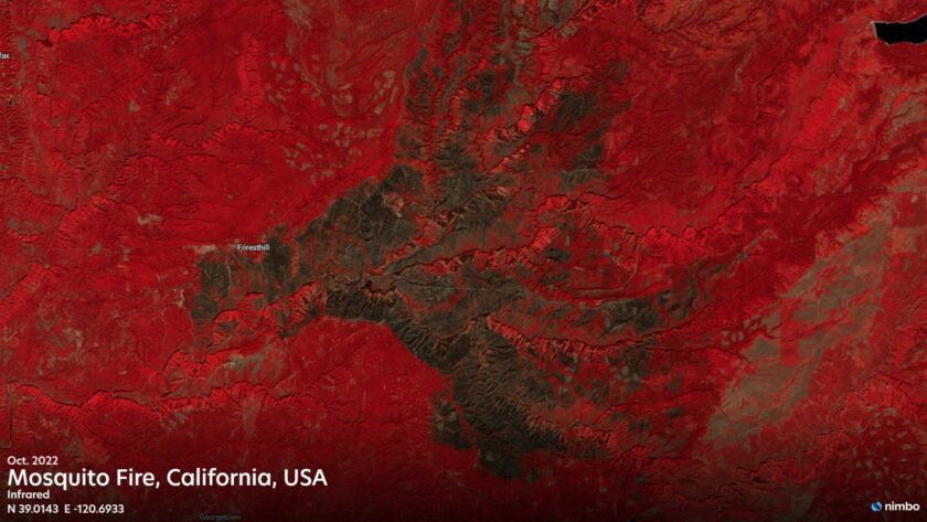
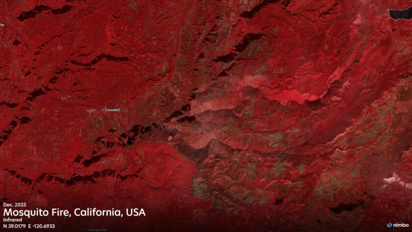
WILDFIRE RISK & FOREST HEALTH
Proactive monitoring for forest health and wildfire risk
Scouting millions of hectares on foot is impossible. Nimbo’s monthly Infrared (NIR), NDVI, and LAI layers reveal vegetation stress long before it is visible to the naked eye. This actionable intelligence allows you to:
- Early Detection: Spot emerging pest outbreaks and drought stress via NIR and NDVI trends, often before ground-level symptoms appear.
- Fuel Load & Burn Scar Mapping: Quantify canopy biomass with LAI to assess fire risk; use NIR to delineate burn scars and SAR for all-weather burn scar detection regardless of cloud cover.
- Rehabilitation Monitoring: Track long-term recovery and forest health with a consistent, cloud-filtered NIR and NDVI baseline.
CUSTOMER STORY
The TreeMap uses Nimbo for its Nusantara Atlas forest monitoring platform
The NICFI Alternative: The TreeMap streams Nimbo’s cloud-minimized monthly basemaps directly into its platform, this enables continuous tropical forest observation and deforestation tracking across Indonesia and beyond.
Nimbo vs NICFI vs Planet TFO
With NICFI’s free satellite imagery fully wound down by 2025, and Planet’s Tropical Forest Observatory starting at $180/month, forestry organizations need a cost-effective, capable alternative. Here is how Nimbo compares.
| FEATURE | NICFI (DISCONTINUED) | PLANET TFO | NIMBO |
| Best RGB resolution | 4.77m | 4.77m | 2.5m (AI – enhanced) |
| Standard resolution | 4.77m | 4.77m | 10m |
| Updated frequency | Monthly | Monthly | Monthly |
| Cloud-minimized compositing | |||
| Spectral Bands | NIR only | NIR only | NIR + NDVI + LAI + SAR |
| Pixel provenance | |||
| 3D visualization | |||
| Archive depth | 2015–2024 | Dec 2015 – Aug 2020, Sep 2020 – Present |
Oct 2019 (Europe) / 2023 (Global) – Present |
| Coverage | Tropical Forest | Tropical Forest | Worldwide |
| Pricing | Free (discontinued) | From $180/month | From $23/month |
| Access and integration | Web apps, GIS integrations, or APIs | Web apps, GIS integrations, or APIs | Web apps, GIS integrations, or APIs |
| Data sovereignty | US-hosted | US-hosted | EU-hosted (France) |
Forests cannot wait. Neither should your monitoring
Nimbo ensures that organizations of all sizes can monitor forests and report transparently regardless of budget. We believe that up-to-date satellite monitoring is a necessity for informed decision making, not a luxury. Empower your mission with the professional evidence it deserves.