Nimbo Soil Cover
Validate sustainable farming actions, at scale
Monitor soil cover with near-real-time satellite data: accurate, early insights for land management, compliance, and sustainability tracking


85%
Average precision of Nimbo soil cover indicators
213 Mn
of hectares monitored since 2018
>10
sustainable farming programs supported by Nimbo data
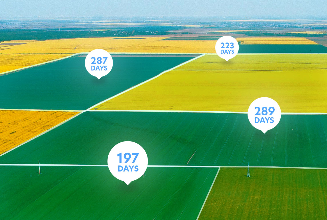
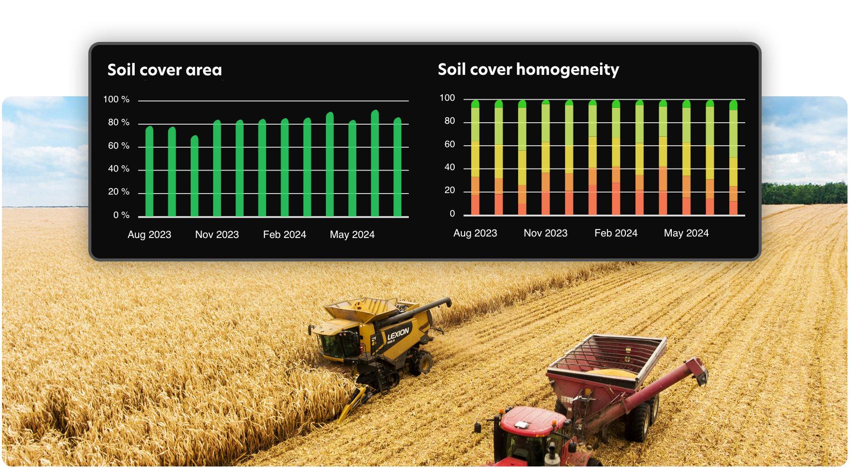
In-depth soil cover tracking
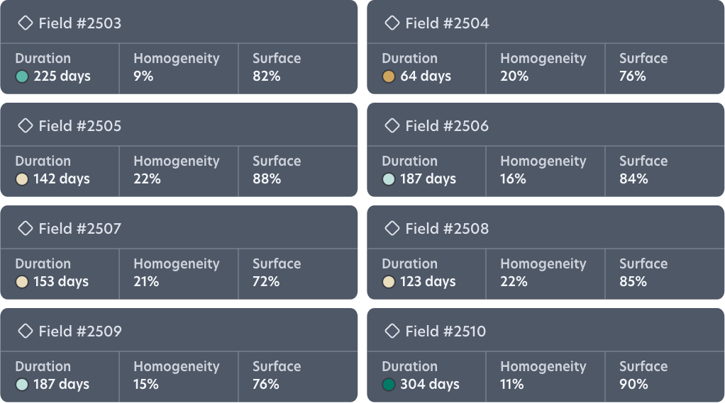
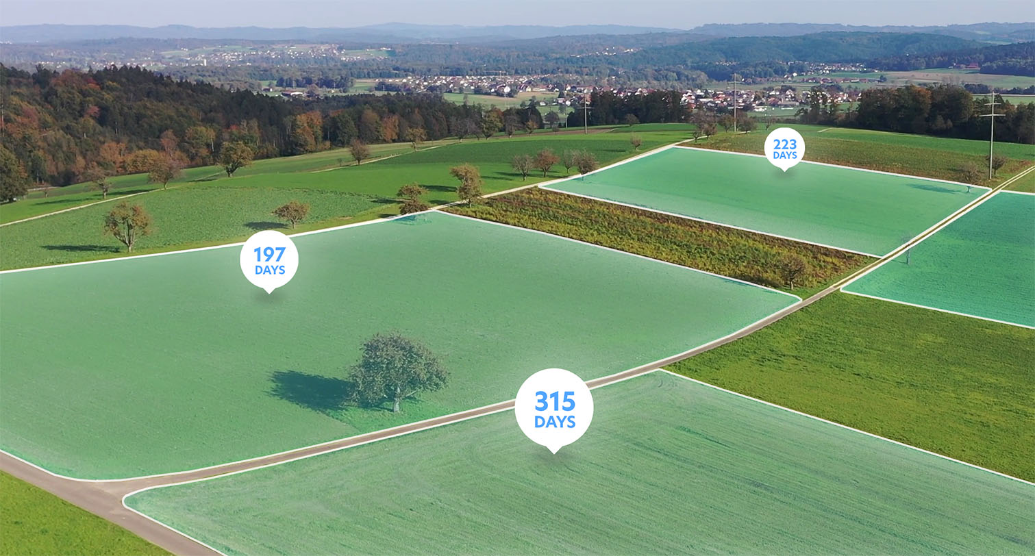
Track vegetation cover’s duration, surface and homogeneity over any area and period with Nimbo’s objective, non-stop remote sensing process, scalable from field to country level.
One of the most reliable solutions on the market, Nimbo Soil Cover relies on a proprietary cloud-masking technology that maximizes data acquisition while preventing cloud-related bias in analysis.
Get the full picture on crop cover
Nimbo indicators include the number of days soil was covered by living vegetation, the proportion of your area of interest that remained covered, and a homogeneity score that reflects spatial consistency in coverage.
Soil cover measurement is supplied with data reliability indices, so you can interpret results with full transparency and reliability.
The shortest way to Nimbo analytics
Discover Nimbo Soil Cover on our Earth Online platform
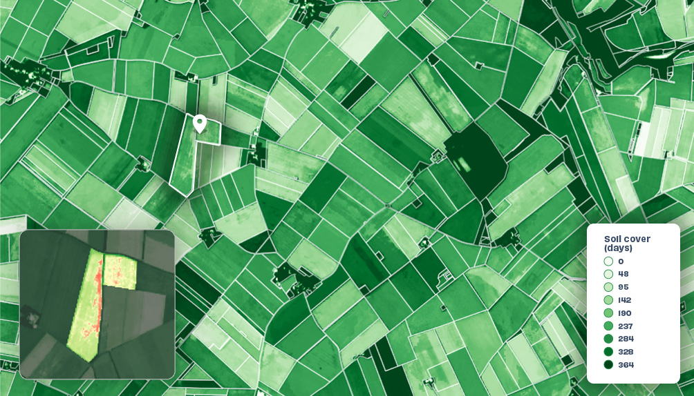
Just the crops you need, at scale
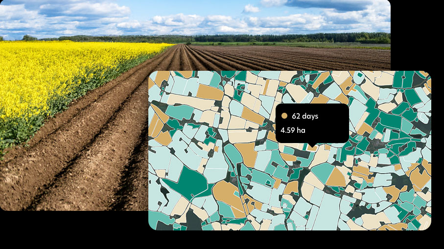
Nimbo’s soil cover monitoring is designed to adapt to your needs—no matter the scale. From individual parcels to national territories, data is delivered with the same level of reliability and precision.
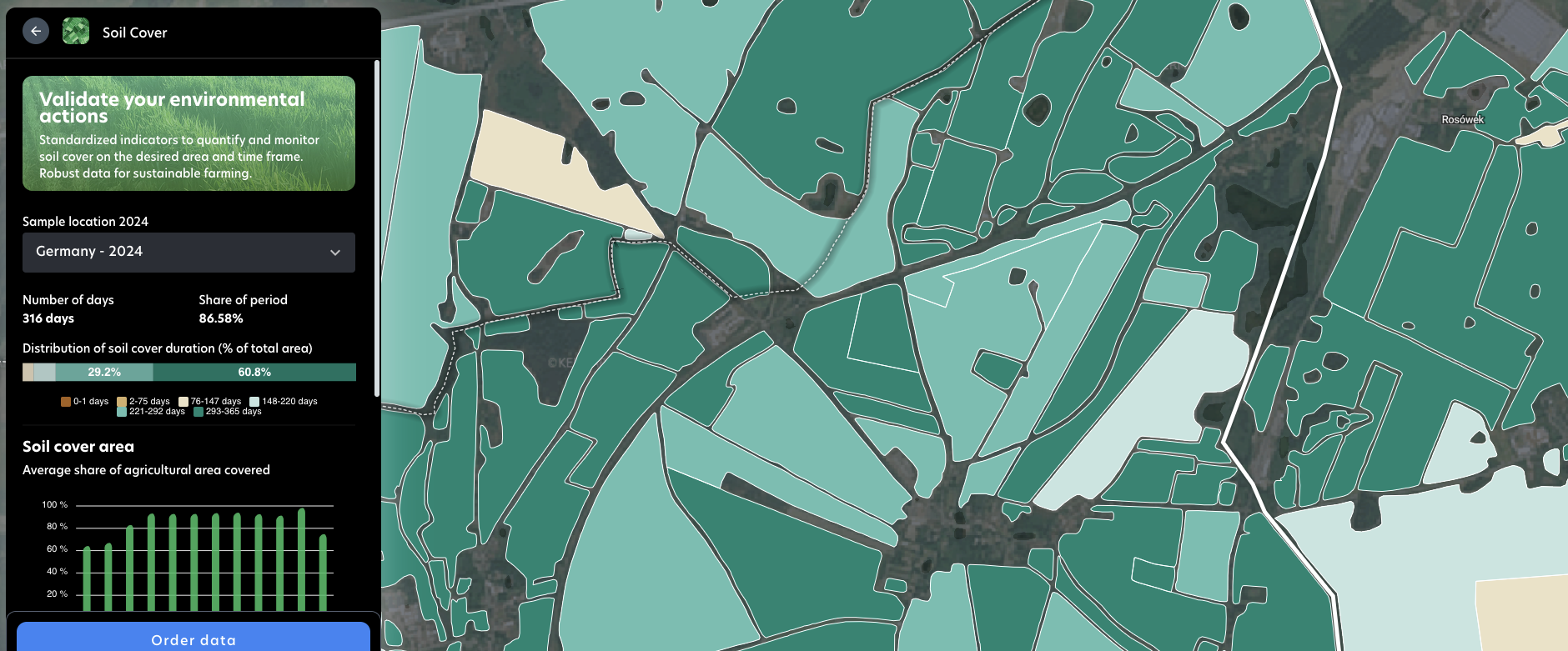
Either zoom in on a single field, or analyze trends across thousands of hectares and filter by crop type to isolate specific soil cover information.
Combine filters with spatial or administrative boundaries for targeted insights to align monitoring with your agronomic goals or policy targets. Whether you’re building a sustainability program or reporting at scale, we’ve got you covered.
Satellite data for regenerative agriculture monitoring
Find out how Nimbo supports regenerative agriculture initiatives (Nestlé, Saint Louis Sucre, Vivescia Group…) to help stakeholders and farmers monitor the implementation of sustainable agriculture practices.
From insights to industry standards
Define new, objective standards for environmental monitoring across your territory with Nimbo Soil Cover. Robust, consistent metrics you can rely on year after year to track evolutions and compare performances with the wider farming area.
With crop identification integrated at field level, our datasets bring unmatched depth and clarity, enabling crop-specific insights and broader territorial comparisons.
The result: a comprehensive, reliable framework that turns soil monitoring into a shared reference for fair and transparent soil conservation initiatives.
This approach is already validated through Nimbo’s participation in major regenerative agriculture programs led by Earthworm Foundation as well as the Transitions initiative led by Groupe Vivescia. Nimbo indicators provide them with shared, objective references to assess practices at field and territorial scales.
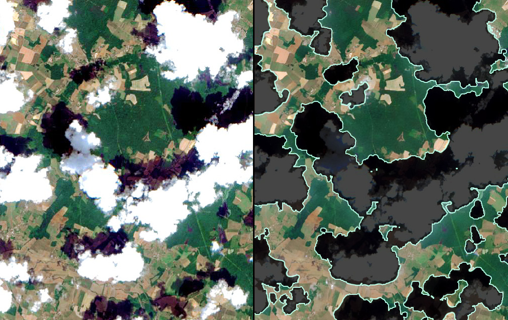
Nimbo cloud mask
Nimbo relies on a proprietary cloud-masking process designed to maximize temporal density across time series.
By filtering clouds at pixel level and aggregating only valid observations, Nimbo preserves continuity even in persistently cloudy regions.
This results in denser, more consistent time series, with fewer gaps and reduced seasonal bias.
Historic Data Since 2018
Non-Stop Monitoring
Your Goals, Your Criteria
Efficient Steering
Objective Assessment
Large-scale monitoring
Nimbo Soil Cover
Track and measure your sustainable farming actions with
field-by-field soil cover analytics, non-stop and at scale
- Soil cover duration
- Soil cover rate
- Soil cover homogeneity
- End of season or In Season
- Bi-monthly updates
Nimbo Soil Cover specs
| Coverage | World on demand |
| Period | Full season or In Season |
| Frequency | Monthly to annual |
| Minimal parcel area | 0.15 ha |
| Trust Indicator | Data availability index |
| Delivery format | Download (CSV) / integration (API) |
| Source | Sentinel-2 (Copernicus Programme), Landsat |
FAQ on Nimbo Soil Cover
What does Nimbo’s soil cover data measure?
Nimbo’s soil cover monitoring provides a detailed understanding of how much of the ground is protected by vegetation, or left bare over time. Using high-resolution Sentinel satellite imagery time series, Nimbo detects and quantifies surface conditions after harvest and throughout the off-season. This information is critical for assessing soil protection, regenerative farming practices, and compliance with sustainable land management guidelines.
By mapping cover levels across all parcels – duration, density and homogeneity, Nimbo Soil Cover provides indicators on participating farmers’ environmental performance. These can then used to measure a farm’s progress over time, and/or be compared with the rest of the farming area to assess its relative efficiency.
Whether you need territory-wide analytics or detailed parcel-level data, Nimbo delivers objective, standardized measurements. These insights are widely used by cooperatives, agri-food companies, and environmental agencies to assess and improve soil stewardship practices at scale.
How often is soil cover data updated?
We provide frequent updates throughout the year, with data typically available every month. This cadence allows you to monitor the evolution of soil cover over time, from the immediate post-harvest period to the start of the next growing season.
Our historical database goes back to 2018, meaning you can analyze multi-year trends and assess how practices are changing over time. This long-term perspective is particularly useful for measuring progress in sustainability programs or verifying adherence to conservation requirements.
By combining frequent observations with consistent methodologies, Nimbo delivers a trustworthy, continuous view of soil management practices year after year.
Can soil cover data be filtered by crop or territory?
Yes. Our analytics can be tailored to match the exact scope of your project or program. Whether you’re focusing on a single crop type, comparing different practices, or analyzing soil cover at a field, farm, or regional scale, Nimbo adapts to your needs. We can filter the data to include only relevant crops or land-use types, avoiding unnecessary noise in the results.
This flexibility means you receive insights that are directly applicable to your objectives—no overwhelming datasets, no irrelevant figures. The ability to zoom in or out also allows you to benchmark practices at multiple scales, supporting both localized actions and high-level policy or program evaluations. This ensures decision-makers can act on precise, tailored information rather than generalized estimates.
How reliable is Nimbo’s soil cover monitoring?
Our solution is built on proven satellite imagery sources, primarily Sentinel-2 data from the European Copernicus program, known for its high resolution and reliability. We combine this data with validated analytical models specifically designed for agricultural soil monitoring. Each step of our processing chain is standardized to ensure consistency across years and regions, enabling fair and objective comparisons.
Independent audits and client feedback confirm the robustness of our approach, giving you confidence in the results. By eliminating the subjectivity of field observations alone, Nimbo provides a solid, evidence-based foundation for environmental assessments, compliance verification, and program reporting. You can rely on our data to stand up to scrutiny from stakeholders, regulators, and certification bodies alike.