As the European Union Deforestation Regulation (EUDR) tightens the rules around global supply chains, producers, traders, and forestry organisations face a critical mandate. They must demonstrate through geolocation data and satellite evidence that their supply chains caused no deforestation after 31 December 2020. This specific date serves as the definitive global baseline against which European authorities will measure every incoming shipment.
Despite two extensions, many operators remain underprepared. Geolocation mapping is incomplete, smallholder supply chains are difficult to trace, and methods previously relied upon, such as manual field audits or basic satellite spot checks, do not meet the evidentiary standard the EUDR demands. The regulation requires a systematic, documented, and repeatable process, and procuring high-resolution commercial satellite imagery for every supply plot individually is neither scalable nor cost-effective for most organisations.
The EUDR guidance explicitly requires operators to use remote sensing methods and GIS-based forest cover maps to verify their land data. For compliance teams, the challenge is securing consistent, cloud-filtered optical data that is accurate enough to anchor a legal Due Diligence Statement.
With the recent simplifications in May 2026, the regulatory landscape is now locked in. The December 2026 deadline is firm.
EUDR timeline: where the regulation stands
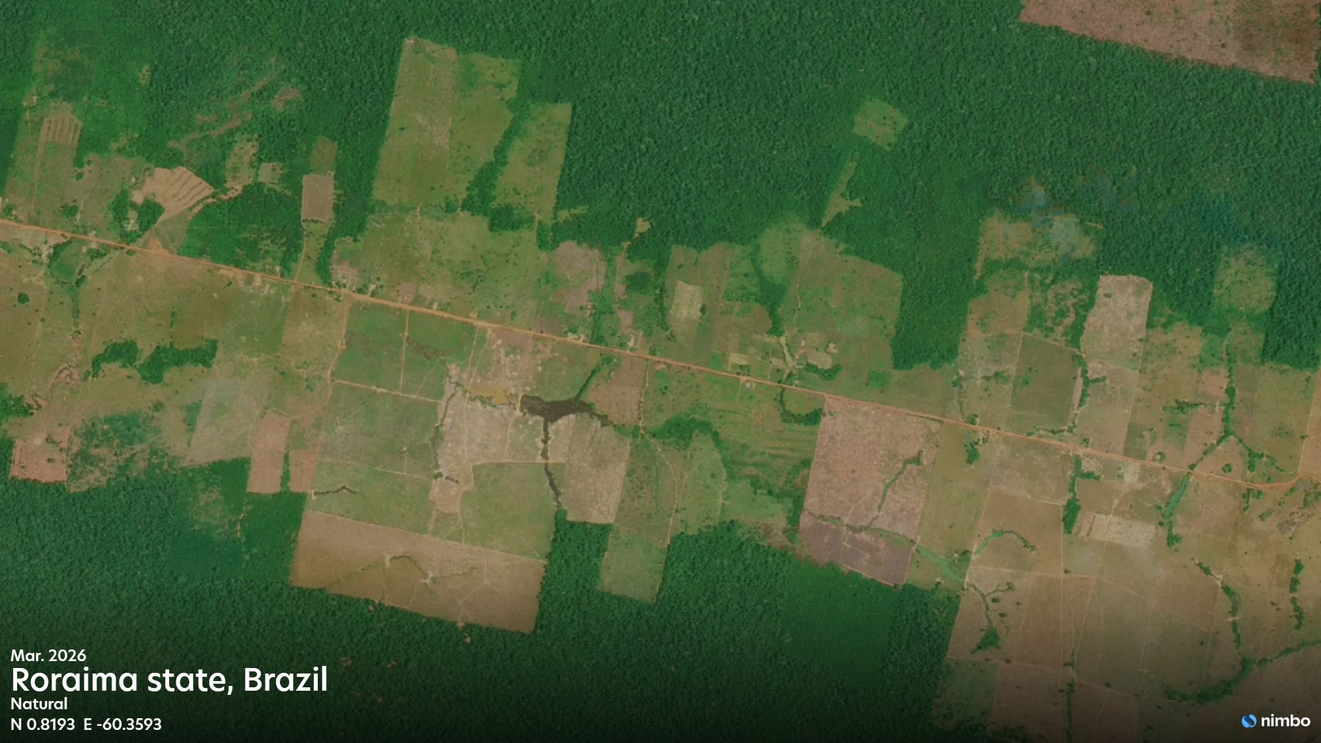
The 2020 baseline challenge
EUDR compliance requires companies to show that a plot of land was not deforested after 31 December 2020. In practice, this means obtaining trustworthy, seamless global coverage imagery of the land from that period to compare against recent data.
Fragmented or cloud-patchy imagery creates significant blind spots for operators. Persistent cloud cover over critical supply regions can disrupt land assessments and stall the entire due diligence process. Compliance teams need a clear, reliable reference layer to evaluate historical forest cover and confidently sort their supply chains.
Nimbo’s Enterprise Plan addresses this directly. It integrates the Copernicus Sentinel-2 quarterly cloudless mosaics for the full year 2020 at 10m resolution into the Nimbo platform, so compliance teams can compare 2020 conditions against current monitoring in the same workflow. Positioned as an efficient screening layer, this 2020 baseline allows organisations to establish a historical reference and quickly clear low-risk plots from their compliance workflows. By filtering out the high-risk areas that require further investigation, this approach saves compliance budgets from being spent on expensive commercial imagery for plots that are clearly safe.
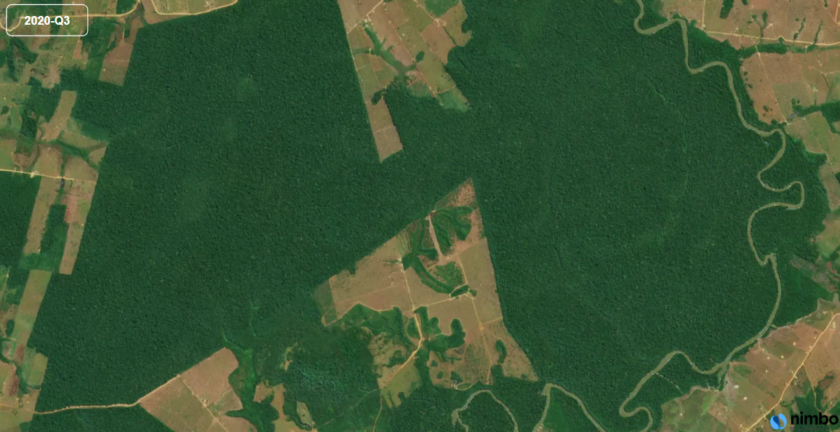
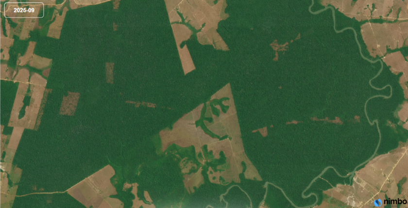
Rondônia, Brazil · Q3 2020 vs September 2025 · Deforestation detected after the EUDR cutoff
Continuous monitoring for complex supply chains
Establishing the 2020 baseline is only the first step. Ongoing compliance requires operators to prove that no deforestation has occurred between the cutoff date and the moment a product enters the EU market. This demands regular visual monitoring of supply plots across tropical regions that frequently suffer from heavy cloud cover.
Nimbo handles this through its 10m monthly basemaps. By processing the full stream of Copernicus Sentinel-2 acquisitions, an AI-driven pipeline automatically selects the clearest pixels to generate a seamless, cloud-free global mosaic that is refreshed every 30 days. Each basemap carries a per-pixel traceability layer recording the source acquisition and month, giving compliance teams a documented evidence trail for any audit request.
While the 10m layer tracks macro-level changes, compliance teams often need finer visual detail to check exact plot boundaries or verify smallholder farms against submitted polygon coordinates. To meet this visual requirement, Nimbo provides its 2.5m HD tier from May 2025. This layer applies AI-powered super-resolution to the 10m Copernicus Sentinel-2 mosaic, delivering a highly detailed view that clarifies land use changes at the micro level.
Accessing this data requires no heavy file management. Nimbo delivers its basemaps via standard TMS/WMTS and APIs, integrating seamlessly into QGIS, ArcGIS, or your own custom platform. This allows compliance teams to inspect any supply plot instantly, without searching for or downloading individual files.
Building a defensible supply chain
The twice-extended application date of the EUDR is often misinterpreted as a weakening of political will. In reality, the delays reflect the complexity of building a global compliance infrastructure. The regulation’s core objectives remain firm: global deforestation has wiped out 420 million hectares of forest since 1990, and the EU is drawing a hard line to ensure its supply chains no longer finance this destruction.
These delays have provided essential time for the EU Information System to mature and for supply chain actors to map their geolocation data. Most importantly, they have allowed Earth observation providers like Nimbo to build the technical infrastructure that compliance depends upon.
For commodity traders and manufacturers assessing their pathway to 30 December 2026, the tools required to build a defensible due diligence case already exist: a cloud-free 10m 2020 baseline and high-resolution 2.5m monitoring.
Start securing your supply chain today. Contact our team to access the 2020 quarterly baseline and integrate Nimbo’s monthly monitoring into your compliance workflow.
Images contain modified Copernicus Sentinel data, processed by Nimbo.